Portions of West and Middle Tennessee are expected to see multiple rounds of severe weather through the weekend, including the possibility of tornadoes and “life-threatening, catastrophic, and potentially historic” flash flooding, according to the National Weather Service.
The NWS office in Memphis said Thursday several rounds of thunderstorms will result in “heavy rainfall and generational flooding,” with 10-15 inches of rainfall expected north of the I-40 corridor through Sunday afternoon and 2-8 inches expected to the south.
An enhanced risk for severe weather is also in effect for West Tennessee Thursday, with “all severe weather hazards” being possible, the NWS said, including wind gusts of 60 mph or higher, hail, tornadoes and flooding.
“Storms could fire up as early as 1 p.m., but most likely in the late afternoon and evening,” the weather service said Thursday.
In Middle Tennessee, rounds of rain are expected to impact the area through Sunday, with the highest amounts expected across the northwest, including in Clarksville and Waverly, where amounts over 6 inches will lead to “significant flooding,” according to the NWS office in Nashville.
Multiple counties in Middle Tennessee were under tornado warnings and watches Thursday morning, according to the Tennessean, part of the USA TODAY network, including Davidson, Williamson, Rutherford and Wilson counties, among others.
Nashville is forecast to see showers and thunderstorms for much of the day Thursday, with some of the storms potentially being severe and producing heavy rainfall, according to the weather service. New rainfall amounts of 1-2 inches are possible Thursday.
Live weather updates: Deadly storms with ‘catastrophic’ rainfall roar across US
Tennessee governor declares state of emergency; 2 deaths, major damage reported in three counties
“As severe storms & flooding sweep across the state, TN has issued a State of Emergency,” Gov. Bill Lee said on X Wednesday night.
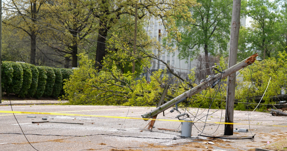
The Tennessee Emergency Management Agency said early Thursday morning major damage has been reported in Fayette, Hardeman, and McNairy counties, and that as of 4 a.m. CDT there were more than 15,400 power outages reported across the state.
The agency said severe weather is expected to resume Thursday afternoon and “will continue through the night for the western and middle regions. In addition, rainfall totals through Sunday are forecast to be up to 15 inches for much of West Tennessee, with some areas possibly receiving more.”
Additionally, TEMA said Thursday the Tennessee Department of Health has confirmed two “weather-related fatalities” – One in McNairy County and one in Obion County.
Dozens of tornadoes reported across multiple states Wednesday and overnight
More than a dozen tornadoes were reported across Arkansas, Illinois, Indiana, Kentucky, and Missouri on Wednesday and overnight, according to the National Weather Service Storm Prediction Center. Images show widespread damage, with roofs collapsed, vehicles overturned and trees snapped and uprooted.
Officials in Missouri said at least one person was killed Wednesday in the southeast part of the state, KFVS-TV reported.
Multiple unconfirmed tornadoes were also reported across Indiana overnight, and the NWS is evaluating tornado damage in Vigo County, Brownsburg, Carmel and northeast of Bedford, according to reporting from the Indianapolis Star, part of the USA TODAY network.
Over 30 million people from Texas to Ohio were still at risk Thursday of powerful tornadoes and major flooding, which is only expected to worsen over the coming days as some parts of the country receive upwards of 15 inches of rain.
What is a tornado warning? How is it different than a tornado watch?
A tornado watch is an alert issued by the National Weather Service. It means that tornadoes are possible in and near the “watch” area. A tornado watch is issued by the Storm Prediction Center for counties where tornadoes may occur, and the watch area is typically large, covering numerous counties or states.
If a tornado watch is issued in your area, the NWS says to be prepared and be ready to act quickly if the next level, a warning, is issued or if you suspect a tornado is approaching.
A tornado warning is the more serious and urgent of the two terms, and means a tornado has been sighted or indicated by weather radar. Tornado warnings are issued by your local forecast office, and typically cover a much smaller area than a tornado watch.
If there is a tornado warning, that means there is imminent danger to life and property and affected residents should take action now, the National Weather Service says.
You should move to an interior room on the lowest floor of a sturdy building and avoid windows. If you’re in a mobile home, vehicle or are outdoors, move to the closest “substantial” shelter and protect yourself from flying debris.
Contributing: Diana Leyva & Kirsten Fiscus, Nashville Tennessean; Emily DeLetter & Christopher Cann, USA TODAY
Gabe Hauari is a national trending news reporter at USA TODAY. You can follow him on X @GabeHauari or email him at [email protected].