- Rainfall could exceed 300% above annual average just over weekend.
- Montgomery County is under a Wind Advisory and Flood Warning on Wednesday morning.
- Another night of severe storms is expected Wednesday night into Thursday morning, as The National Weather Service upped to moderate weather on its scale.
Montgomery County’s severe weather woes aren’t over. Severe weather will rev up across the county Wednesday night into Thursday morning, the National Weather Service predicts.
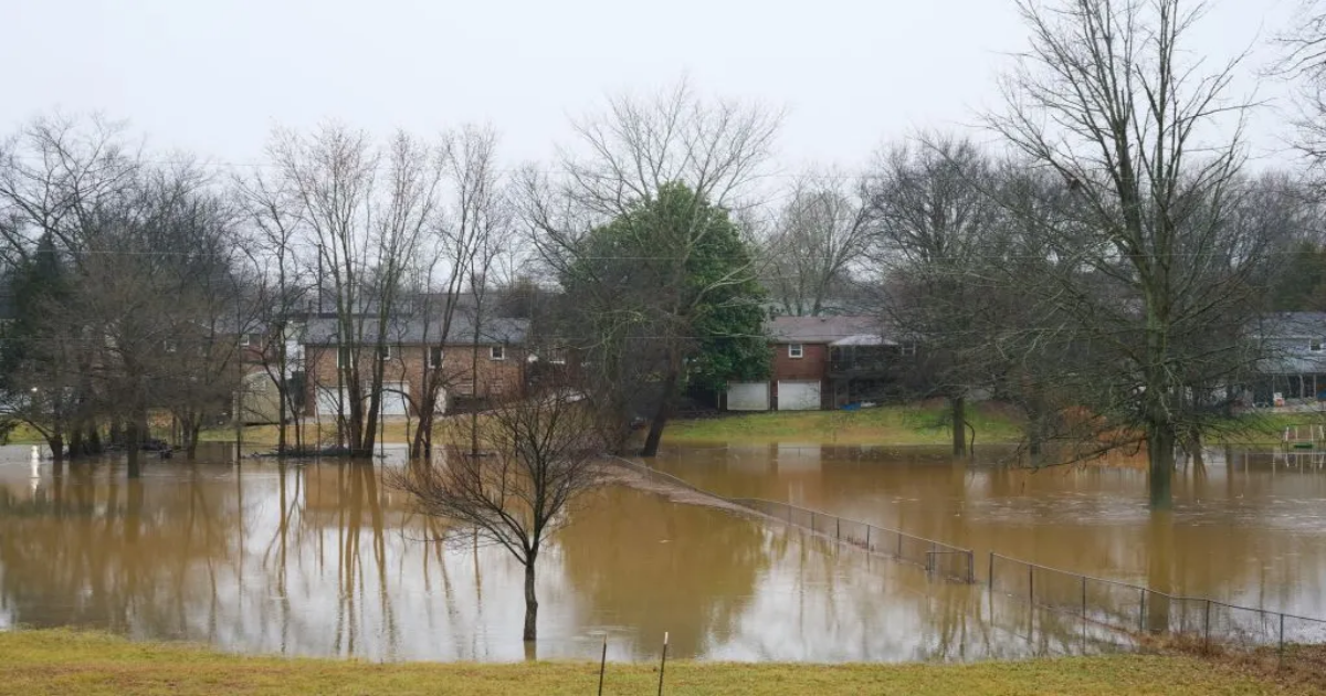
Rainfall could exceed 300% of the annual average over the next several days, according to Montgomery County Highway Department personnel.
As of Wednesday morning, Clarksville is under a Wind Advisory, with winds expected to reach up to 45 miles per hour from 10 a.m. Wednesday to 4 a.m. Thursday.
The NWS has escalated Montgomery County to a moderate weather lookout from 9 a.m. Wednesday to 6 a.m. Thursday morning.
Damaging winds, large hail, tornadoes and heavy rain are all possible, especially in the northwest areas.
Some areas could see up to 8 inches of rainfall, only a month after the last heavy rain.
A Flood Warning in Montgomery County is in effect until 7 a.m. April 6.
More: Tennessee Gov. Bill Lee tours Clarksville to assess flood damage
Highway department monitoring flooding
The Montgomery County Highway Department said it is closely monitoring the severe weather conditions and taking proactive measures to mitigate potential hazards.
“Predictions indicate rainfall totals of up to 10 inches, which would bring our annual precipitation to over 300% of the average,” said Joshua Peltz, Montgomery County Highway Department Aerial Media Specialist. “This significant rainfall heightens the risk of flooding and may lead to road closures and infrastructure damage.”
Peltz said the department has focused efforts on shoring up areas such as Cooper Creek Road and clearing culverts and bridges to ensure stormwater can flow freely.
The highway department anticipates the roads will be susceptible to flooding and potential closures following the February flooding. Some areas of concern are:
- International Boulevard
- Kirkwood Road
- Dunlop Lane at both Rollow Lane and Boyer Farms
“In addition to these risks, we are also expecting the possibility of road washouts similar to those experienced during last month’s storms,” Peltz said.
The department will keep real-time updates and provide more information on its Facebook page.
Watch vs. Warning?
As severe weather begins to move through Montgomery County, residents will surely receive a notification of a weather watch or warning.
What’s the difference and when should you be more concerned?
A warning issued is more severe than a watch.
A thunderstorm or tornado watch means this weather is possible and near the area. During a watch, residents should ensure they have a safe location to go to in case the weather worsens.
A thunderstorm or tornado warning means that the weather radar has spotted the severe weather and that there is imminent danger. Residents should take cover and get to a safe location immediately.
If a tornado warning is issued, you should:
- Seek shelter immediately
- Get into a basement or small, interior room on the lowest level
- Stay away from windows, doors and outside walls
If in a vehicle
If you’re outdoors or in a vehicle during a tornado warning, the Tennessee Emergency Management Agency recommends taking cover in a stationary car and buckling up.
The agency recommends putting your head below the windows and covering it with your hands, using a blanket, coat or other cushion if possible.
If driving upon flood waters, emergency officials tell drivers to “turn around don’t drown” as cars could be swept away in moving water.
Severe weather tips
- Have multiple ways to receive weather updates
- Have an emergency plan and kit ready to go
- Keep your phone fully charged
- Have Wireless Emergency Alerts enabled
- Sign up for a storm alert app, like Storm Shield, which sends alerts based on your location
Clarksville 5-day forecast
According to the National Weather Service, severe thunderstorms are forecasted through Sunday in Middle Tennessee and Montgomery County.
Wednesday: Showers and thunderstorms, mainly before 2 a.m., then possible thunderstorms after 2 a.m. Southwest wind 10 to 20 miles per hour
Thursday: Showers and possibly precipitation, some could be severe, 90% chance of precipitation
Friday: 70 percent chance of precipitation, wind gusts as high as 20 mph during the day, 30% chance of rain at night
Saturday: 60% chance of precipitation, with wind gusts as high as 25 mph, 100% chance of rain at night with wind gust as high as 20 mph
Sunday: 50% chance of precipitation, with wind gust as high as 20 mph
Kenya Anderson is a reporter for The Leaf-Chronicle. She can be contacted at [email protected] or on X at kenyaanderson32. Sign up for the Leaf-Chronicle to support local journalism at www.theleafchronicle.com.