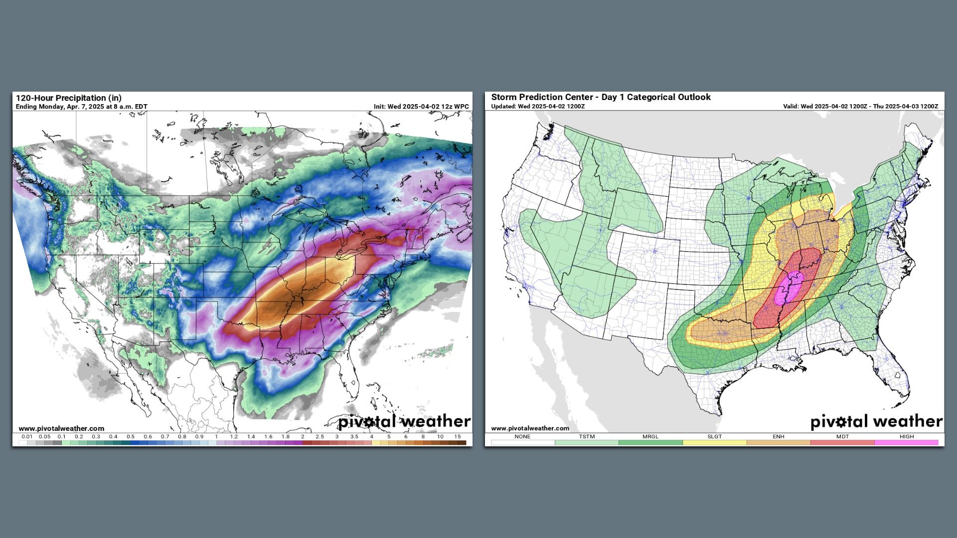
 Maps showing precipitation forecast totals on the left and severe thunderstorm risk on the right for April 2, 2025. Images: Pivotal Weather/NOAA
A highway of moisture flowing off unusually warm waters — combined with an intense storm system — will result in dangerous flooding from Arkansas through the Ohio and the Tennessee valleys over the next few days.
Threat level: In the hardest-hit areas, rainfall totals could reach a few Aprils’ worth in just four to five days.
- The National Weather Service is warning of an “increasingly significant setup” with the potential for “catastrophic” flooding in the hardest-hit regions.
- It is forecasting rainfall totals that could exceed 15 inches in some locations, describing it as an “extreme flooding scenario.”
- Forecasters will be closely watching as rains add up in the Mid-South, particularly across northeastern Arkansas, northwestern Tennessee and western Kentucky.
State of play: The flooding is only one of this upcoming storm’s hazards, as a powerful and slow-moving low-pressure area slides across the Central states and Midwest.
- Severe thunderstorms with the threat of damaging winds and a large-scale, “major” tornado outbreak are forecast on Wednesday and Wednesday night across the Mid-South.
- The Storm Prediction Center is predicting a “high risk” — or level 5 out of 5 on its scale — of severe weather in the mid-Mississippi Valley to the Lower Ohio Valley on Wednesday into Wednesday night, including the threat of “[n]umerous tornadoes, along with multiple long-track EF-3+ tornadoes.”
- Cities in the high risk zone include Memphis and Jonesboro, Tenn., with Louisville, Little Rock, Ark., Evansville, Ind., and Bloomington, Ind., in the moderate risk zone.
To top it off, heavy snow is forecast for parts of the Dakotas, Minnesota and Wisconsin as seasons collide.
Context: Extreme precipitation events are becoming more common and severe due to climate change, as warmer air temperatures hold more moisture.
- A marine heat wave in the Gulf of America (renamed by the U.S. from the Gulf of Mexico) and the Caribbean — a phenomenon increasingly tied to climate change — is also a factor, since this area will be the moisture source region for the heavy rainfall.
In another sign of the event’s unusual nature, there is the potential for some spots to set records for the amount of precipitable water in the atmosphere.
- This is a way of measuring the precipitation that would result if all of the moisture in a column of air were to condense and fall as rain.
The extreme weather comes amid the Trump administration’s push to give states the lead role in disaster response and recovery, potentially dissolving FEMA.
What we’re watching: Where the heaviest rainfall sets up, and how severe the ensuing flooding gets.


